 |
|||||
| Home | Westwind Mine | News Archives | Mailing List | Links | Calendar |
|
LEE COUNTY SMART GROWTH JULY 25, 2007, ESTERO COMMUNITY PARK AND
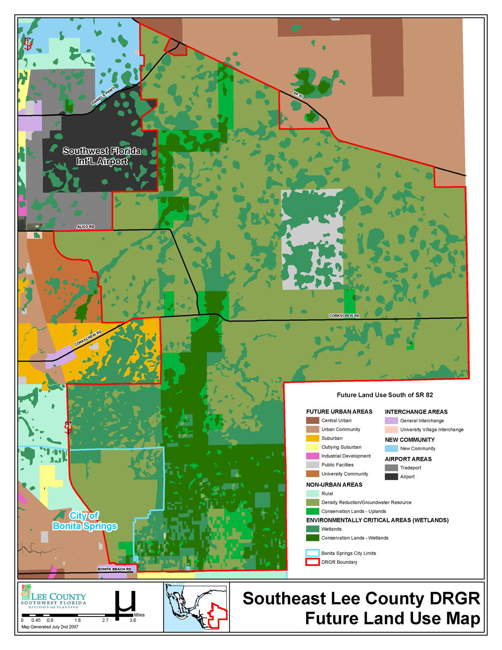
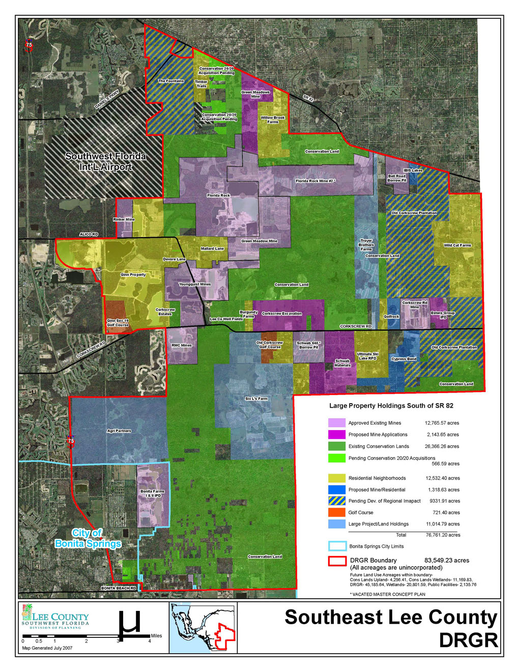
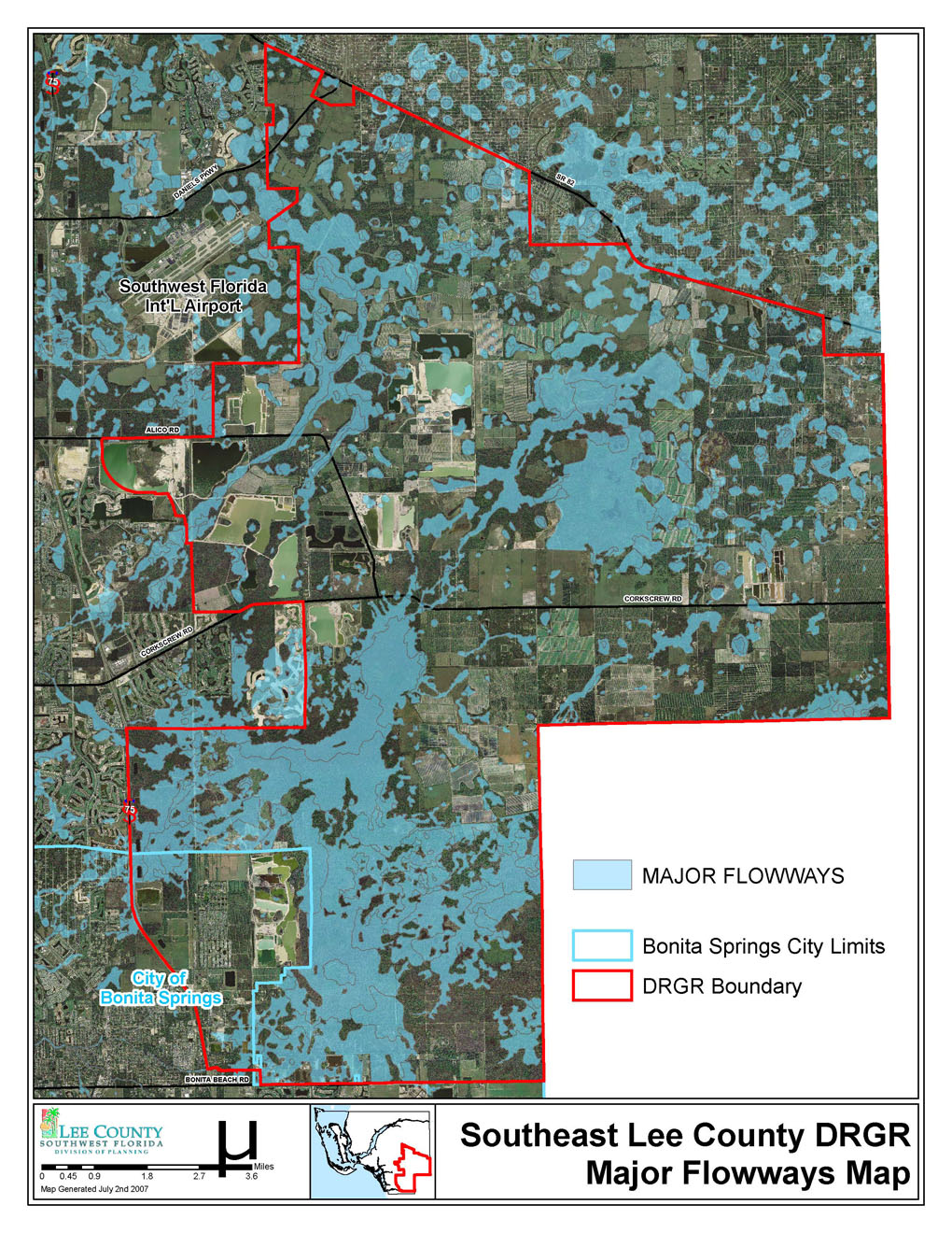
RECREATION CENTER, The Lee County Smart Growth Committee is hosting a community issue session, on July 25th, at 6pm. The purpose of the workshop is to solicit the viewpoint of the stakeholders and general public on the critical issues that speakers (or comment writers) believe confront this vital part of Lee County. The results of the workshop will be presented to the Lee County Board of County Commissioners at its Management and Planning meeting of August 9th, 9 am, at the Board of County Commissioners’ Chambers. The question being asked at the workshop on the 25th is: “What are the critical issues you see facing the DRGR now and in the foreseeable future?” To assist speakers and the general public, a summary of information, and links to additional information sources, is provided below. The Committee and staff will have information set up at the Estero Community Center at 5pm, July 25th, and will be available to answer questions to the best of their ability. SOUTHERN DRGR SUMMARY SHEET Background The Southern Density Reduction/Groundwater Resource (DRGR) area is an 83,410 acre area in southeast Lee County, roughly bordered by I-75, Treeline Boulevard, the SWF International Airport, and State Road 82, and the County lines of Collier and Hendry Counties. The area is a recognized natural water storage area, and three different wellfields are currently in operation for public and private water supplies. The area was formally recognized as a water resource area and designated as an area for very low density residential use as part of the County’s Local Government Comprehensive Plan, pursuant to the 1985 Florida Growth Management Act of 1985. The designation and geographic application was adopted in 1991. The full Comprehensive Plan is found on this website: http://www.lee-county.com/dcd Uses and Activities in the Southern DRGR There are five primary land uses within the DRGR. These include very low density residential, with a rough allowance of one unit per 10 acres; agriculture (citrus, row crops, and pasture); mining; open space recreation (golf courses); and, conservation. In addition to those uses is the separate land use category of wetlands. Wetlands permeate the DRGR area, and have a very low residential density of one unit per 20 acres. The largest land use is conservation, and is a blend of water management district preservation property, county owned conservation property, and private mitigation banks. Mining occurs within the DRGR in areas with the better marketable rock. Several of the mining activities are quite large, and the mining within the DRGR is one of the most important resource areas for mine quality rock in Florida. (Source: Strategic Aggregate Study: Sources, Constraints, and Economic Value of Limestone and Sand in Florida, Lempl Herbert Consultants, Tallahassee Florida, March 12, 2007.) Mining is potentially the land use with the biggest increases expected, due to the ongoing demand for mined materials for urban growth and infrastructure fill, such as for road beds. Agriculture as a land use designation covers a variety of activities of differing intensities, from unimproved pasture to row crops to citrus. Some agricultural lands have been adversely affected by market conditions, and owners have a strong interest in converting property to land uses more intense than the current land use planning allows. Agriculture is expected to be a declining land use activity if the other uses begin to expand. Open Space recreation’s dominant use is golf courses. The number of courses has not expanded to meet the expected use of this category. Residential exists, and varies from a single domicile on a “stand alone” parcel, to parceled or subdivided acreage with individual housing, to clustered housing on smaller parcels with broader open spaces. Often, the residences are tied to small scale agricultural activity. There are also vested existing subdivisions and development of greater intensity. Additional residential at low density has acreage where it can occur, but speculative pressure has deferred some that had been expected. Information on Environmental Values The Density Reduction Groundwater Resource area has been the focal point of a number of studies, and the area has also been included within assessments of the resources of larger areas. The greater part of these studies has been included in a just completed review of literature on the environmental values of the DRGR. The report, Review and Summary of Studies Containing Information Relating to DRGR Lands, Southeastern Lee County, McLane et al, May 2007, is online and can be downloaded at: http://www.lee-county.com/dcd/Downloads/DRGR.htm The report summarizes the content of 14 studies, and draws a conclusion about the degree of information contained. In summary, the report affirms the presence of the environmental values which the Lee comprehensive plan states deserve protection. Current Management and the Future of the DRGR Resource Management in the Density Reduction Groundwater Resource area is divided among different public agencies. The two primary agencies are the Lee County Commission and the South Florida Water Management District. The Lee County Commission determines the overall development density and intensity for land uses. It also operates two utility wellfields, and is the developer of expansions of the County road system proposed within the DRGR. The County Commission, either as the Commission or as the Lee County Port Authority, also manages the greater part of the public land acquisition programs that occur within the DRGR. The South Florida Water Management District is the primary agency with the responsibility for managing the quality and volume of water resources throughout South Florida. “Consumptive Use Permits” and “Environmental Resource Permits” provide for water use and drainage/flood control activities on private property. SFWMD coordinates with the other State environmental agencies. There is also a Federal presence in federally designated jurisdictional waters, which commonly includes major wetlands with a likely connection to jurisdictional navigable waters. The lead Federal agency is the US Army Corps of Engineers, which undertook an Environmental Impact Statement (EIS) on growth in Southwest Florida. Current and future public management of the County designated DRGR area is through those agencies. It should be noted that the City of Bonita Springs at the time of its cityhood included a portion of the DRGR designated area. That portion has not been included in this workshop, since the City is undertaking its own assessment of the future of the DRGR within its boundary. Descriptive Mapping. A number of maps are included to give a better understanding of the DRGR. These include:
|
|||||
|
Website provided by
ImageGrafix - Computer and Network
Systems - Site Hosting
Solutions |
|||||